At the end of 2022, Arkansas State Parks introduced Club 52, a reward program for those participating in their Arkansas State Park Passport Program. The Passport Program was created to encourage Arkansans to visit their state parks. As a way to document which parks they have visited, visitors receive a stamp at each park. Club 52 puts more fun into the state park journey, as you can collect prizes for a certain number of stamps collected. Families all over the state have enjoyed and are enjoying achieving each level of prizes. The ultimate goal is to visit all 52 Arkansas State Parks. Thankfully, there is no time limit and visitors can complete (or not complete) their passport at their leisure.
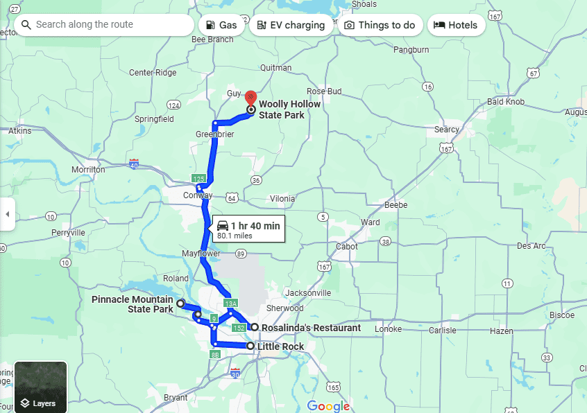
So, what is the best way to complete your Arkansas State Park Passport? Follow our State Park Itineraries for the best way to maximize your passport! Please note that this series of itineraries starts from Little Rock since the center of the state is just outside of city limits.
To start our state park passport, there are actually a few parks in the Little Rock area. So, we are going to start our journey at Pinnacle Mountain State Park.

Directions from the Little Rock city center:
- Take I-630 W
- Take Exit 8B to merge onto I-430 N
- Take Exit 9 for AR-10 W/Cantrell Rd.
- Follow AR-10 W/Cantrell Rd.
- Turn right onto Pinnacle Valley Rd.
- Follow Pinnacle Valley Rd to Pinnacle Mountain State Park
Stop 1: Pinnacle Mountain State Park
Pinnacle Mountain is the centerpiece of this state park. There are plenty of outdoor activities here, with the Big and Little Maumelle Rivers, Arkansas Arboretum, 22 miles of hiking and mountain biking trails, and interpretive programs. They recently built a new visitor center that is host to Loblolly Outpost.
While you are here, be sure to at least hike to the top of Pinnacle Mountain. It is a rocky hike that leads down the mountain and then up it. Remember to take plenty of water if you are hiking in the summer! The view from the top is amazing and there is even a bench for you to catch your breath. Along the way, you’ll walk over bridges and creeks as you navigate the semi-rocky ground. Even though the trail is well established, it is also clearly marked on the trees.
Not only can you get your State Park Passport stamp here, but you can also get a Trail of Tears stamp. Pinnacle Mountain State Park is a certified Trail of Tears National Historic Site as it saw the removal of the Cherokees, Choctaws, Creeks, Seminoles, and Chickasaws. Please note that there is not a Trail of Tears passport book like there is an Arkansas State Park and National State Park Passport Book. A very nice interpreter encouraged me to use a Trail of Tears brochure for my stamps, as stamps can be geographically placed on the map inside. That is how I collect and store my Trail of Tears stamps, so you will need to figure out a system that works best for you.
Stop 2: Lunch
After leaving Pinnacle Mountain State Park, we are going to back track just a little for lunch and then route to just over an hour north to Woolly Hollow State Park. But first, we are stopping for lunch at Rosalinda’s Restaurant, a very delicious and causal Honduran restaurant.
Directions to Rosalinda’s Restaurant from Pinnacle Mountain State Park:
- Head southeast on Pinnacle Valley Rd.
- Turn left onto AR-10 E/Cantrell Rd.
- Take ramp onto I-430 N
- Take exit 13A to merge onto I-40 E toward Memphis
- Take exit 152 for AR-365/MacArthur Dr. toward Pike Avenue
- Follow AR-365/MacArthur Dr.
- Turn right onto Doyle Venable Dr.
- Turn right onto Burks Avenue
- Turn left onto W 33rd St.
- Turn left onto Schaer St.
- Turn right
- Turn right
- Rosalinda’s Restaurant will be on the left
After eating lunch, we are going to continue to our next state park – Woolly Hollow State Park.
Directions from Rosalinda’s Restaurant to Woolly Hollow State Park:
- Head west toward Schaer St
- Turn left toward Schaer St
- Turn right onto Schaer St
- Turn right onto Camp Robinson Rd
- Turn left onto W 37th St
- Continue onto Doyle Venable Dr
- Take ramp onto I-40 W
- Take exit 125 to merge onto US-65N/Skyline Dr
- Follow US-65 N
- Turn right onto Hwy 285 E
- Turn left onto Woolly Hollow Rd.
Stop 3: Woolly Hollow State Park
One of the things that I love most about Woolly Hollow State Park is their visitor center. This is the only state park where I have seen a completely park branded gift shop. Almost every single thing was branded Woolly Hollow, and it was such a neat experience. Things may have changed since I was there last, though.
Anyway, Woolly Hollow State Park is the perfect day trip. Everything here is centered around being outdoors. The park offers camping, fishing, swimming, boating, hiking, and biking. Located in Greenbrier, it feels like you are in your own little world when visiting.
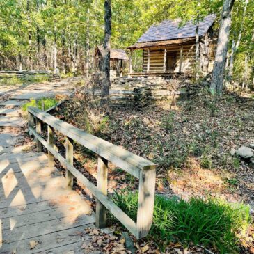
Built in the 1930s, the 40-acre Lake Bennett was the Soil Conservation Service’s first watershed project. The park offers canoe, kayak, and pedal boat rentals for visitors to explore on the water. Also unique to this state park is that it is host to Woolly Hollow Cabin, an original 1882 one-room family homestead. While the park offers several hiking trails, the cabin is located just behind the visitor center and very easily be walked up to from the road. At the cabin, you’ll cross a bridge that is a great place for a photo opportunity. Do not forget to check out the well located next to the cabin.
Woolly Hollow State Park is best visited in the spring and summer before the dry season. When Arkansas enters its dry season, the lake will be too low, and you will not be able to enjoy it. However, if you are just state parkin’ and collecting stamps, then visiting any time of the year will be rewarding.
After your stop at Woolly Hollow State Park, you can choose to camp overnight (or the weekend) and enjoy the first day of Arkansas State Parkin’ or head on back home. At the end of the day, you should be going home with:
2 state park stamps
1 Trail of Tears stamp
What was your favorite part of the day?

